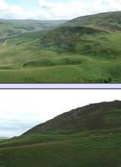
Landslides are very common in the Dark Peak, especially on Snake Pass (e.g. the Lady Clough landslide) and the Longdendale valley.
On an OS map, these landslips are visible by the tight series of arc-shaped contour lines running parallel to the reservoir with a flatter area behind. Long Gutter Edge is one of these landslips.
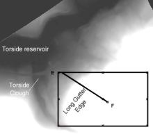
The diagram on the right is a digital elevation model (DEM) - the lighter the colour, the higher the ground. The box shows the position of the block diagram of the landslips below.
The profile line EF shows the position of the valley cross section where you can see the landslides' shape.
Location of the Long Gutter Edge Landslide.

This block diagram right shows the landslip at Long Gutter Edge - it corresponds to the box drawn on the DEM above and on the location map.
Using ideas from the Alport landslip site, can you see where the back of the landslide and the lip of the slumped material are located? Some answers.
See the effects of recent storm events.

The profile right is a slice through the block diagram along the line EF.
The HyMap image right shows the location of the profile and the land cover types.

See a ground view of the profile where you can see the Longdendale Trail and National Trust visitors centre.
See the annotated aerial photograph of the Torside area again.
To see a 1:25,000 OS map of the Torside region, go to the Get-a-Map website, and enter the grid reference SK073972 into the search box.

Finally, here is a new view of the area, this time a digital elevation model (DEM).
It is a southwesterly view over the Torside Reservoir towards Bleaklow.
This is the last step of the tour, if you need to revisit a stop, go back to the tour menu now.
Or
Use the links above to continue your exploration of the Dark Peak.
Previous site <: 7. Torside - Long Gutter Edge vegetation
Start of tour <