
Further north from Alport Moor are the Hern Stones, protruding boulders of Kinderscout Grit.

Click on the image to the right to see the vegetation of the area and how hummocks and hollows (as you saw in Alport) can be further degraded.
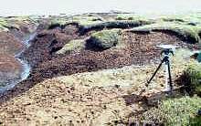
The hummock-hollow landscape (as described at Alport) has been further degraded.

What vegetation types can survive these conditions? Click the image right to enlarge and see labels...

Peaty pools occur around this area. The peat is moved (mainly by water) from the sides of haggs and redeposited in pools below.
Click the image right to enlarge.
Large gullies drain west and south from the area, They cut through the landscape, further eroding valley sides. Different degrees of peat humification create a patchwork of different peat colours
Click the image right to enlarge and explain further.

The gullies and the complex topography can be seen on this aerial photo.
Click image right to enlarge and add labels (WARNING - large images on this page).

This picture shows a peat hagg looking up from the grough below.
Overhanging vegetation on the hagg top occurs when the hagg side has been undercut so it becomes top heavy.
Haggs are in the acrotelm layer of blanket peat, they dry out at the top and thus humification is more advanced here. It then acts as an aeration zone where water flows laterally through the hagg tops as near surface runoff.
The unvegetated hagg sides (which are now top heavy and drier) are vulnerable to further erosion by water (from lateral flow within the peat, rain and flow around its base) and wind. Recent erosion on hagg sides can be identified when plant roots protrude from the hag sides.
Once you're happy with the hagg and grough landscape seen at the Hern Stones, lets go up to Bleaklow Head, a high plateau further to the north where you'll see examples of more extreme peat erosion.
> Next site: 5. Bleaklow.
< Previous site: 3. Alport Low.
< Start of tour.
