Northwards from Hern Stones to Bleaklow Head the plateau reaches a height of over 633m (2,000ft)
How do you get there?.
The plateau top experiences unpredictable and harsh weather conditions where cloud cover is frequent and sunshine amounts to no more than 1000 hours a year (these photos were taken on one of the rare sunny days!). The summit is often below the cloud base and it is very easy to get lost. Bring your compass or GPS.
Over 150 mm of rain can fall over a matter of hours, completely saturating the peatlands. This high rainfall is necessary to maintain peat formation in the area (refer to the acrotelm/ catotelm page, or the peat themes page).
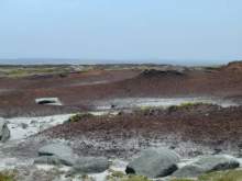
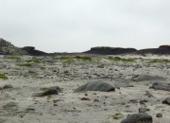
Its exposed position has made the plateau very vulnerable to the erosional agents of wind and water, which have created a 'beach like' appearance (photo right)where the peat cover has been completely removed exposing the underlying rocks, boulders and glacial mineral soils.
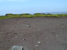
This exhaustive peat erosion has made revegetation of the area slow.
Erosion is also exacerbated by sheep grazing and trampling by walkers.
What sort of species do you think has the ability to colonise these harsh conditions? Find out more...
Have another look at the aerial image and identify the revegetated areas around Bleaklow Beach.
> Next site: 5. Bleaklow from the air.
< Previous site: 4. Hern Stones.
< Start of tour.