
The landforms seen at Lady Clough are one of Britain's largest landslides.
The main mass movement took place some time after 8,300 yrs B.P.
The photo (right) shows the landslip at the bend in the A57 at Ladyclough, looking south-west, down from Nether North Grain over Featherbed Moss.
Enlarge the photo and add labels.
They huge slope failure occurred due to the combined result of glacial activity and geological structure:
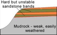
- The lower mudrock layer became deformed and weakened.
- Glacial action exposed the upper layer of thin sandstones bands - these acted as aquifers, creating high water pressures, weakening the strata.
Combine these factors with:
- Overlying buttress cap rock of Millstone Grit.
- Elevated water tables.
Find out more about the process of critical slope failure

The block diagram (right) shows the landslip above and was created from digital elevation (DEM) data and is labelled in the same way as the field photo you saw previously.The high plateau in the background is Featherbed Moss.
The A57 runs along the valley bottom.
See the effects of a recent storm event.
The next stop on your tour is Alport Moor - how do you get there?
> Next site: 2. Alport Moor.
< Start of tour.