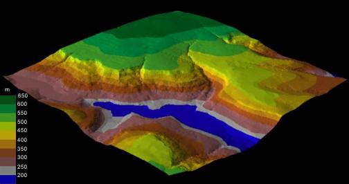
This block diagram represents the terrain looking back south towards Bleaklow.

- Made from a DEM and is colour coded from blue for the lowest elevations, through grey, brown red orange and yellow - to green for the highest terrain.
- Blue is used for ground below 200m (not the water level in the Reservoirs).
- It is more or less correct for Torside Reservoir, but too low for Woodhead Reservoir (approx. 250m) and Rhodeswood Reservoir (approx 180m).
- This is why Woodhead Reservoir is not shown as blue and why Rhodeswood's representation is too large.
How many other feature you identify?
Can you see any other landslides?