Geology of the Peak District

- The underlying rocks of the Peak District were laid down during the Carboniferous age,except for locally occurring sands, clays and gravels, and some sporadic thin deposits of Pleistocene and Recent ages.
- Hence the rock in the area are described as Carboniferous rocks.
- These were deposited when what is now Northern England was covered by the waters of the Carboniferous Sea.
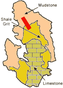
- The marine sediments comprise of sands, gravels, muds and detritus laid down during this period produced rocks of three basic types which are found in the Peak District as shown in the diagram opposite.
- Limestone.
- Shale Grit.
- Mudstones.
- A thinner upper group of shales, sandstones and thin coal measures are also to be found in the area, as are locally occurring coals and clays.
Geology of the Study Area: Namurian Rocks
The majority of the rocks in the study area (the approximate position shown as the red box above) were deposited during the Namurian Series, mostly during the Kinderscoutian stage, c. 320 Million years ago.
- Sedimentation in the South Pennines during this period gave rise to more than 2,000 metres of clastic deposits.
- Most (but not all) are Sandstones, Mudstones or Conglomerates.
Cyclic Deposition
- Sedimentation during Namurian times was cyclic.
- This created breaks in the sediment layers, creating a series of rock successions (cyclothems).
- Major breaks in sedimentation are thought to be associated with eustatic sea-level changes, especially sea-level low-points.
Origin of the Sediment
- A series of major fluvial valleys (now termed paleovalleys) flowed southwards from the north-east into what is now the northern Peak District.
- Sea level rise during the Kinderscoutian stage, promoted development of unstable shelf edge deltas.
- These deltas were supplied by the south flowing river systems.
- The direction of sediment transport, combined with the shape of basins, explains the thickness trends of the stratigraphy.
Underwater Basins
- Sea water depths in the Namurian period reached up to a few hundred metres in many sub-basins (e.g. the Edale Basin).
- As sea levels rose the sediment supply from fluvial valleys began to exceed accommodation space - the basins were then infilled by the overflow of fluvial and deltaic sediments.
- This 'infilling' of the basins' valley bottoms with sediments resulted in sheet-like deltaic stratigraphy shown opposite.
Mudstones
- As sea level rose, these sediments accumulated and compressed, forming what are now termed mudstones.
- These are fine grained rocks (<63 micrometres), composed chiefly of particles in the silt - clay size range.
- There are 3 units of formations found in the study area. Find out more on the next page...