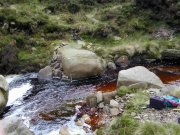
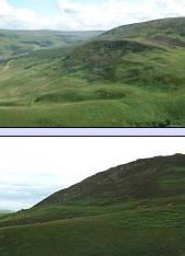
The Longdendale valley is surrounded by high plateaux of blanket peat, which drain into the valley by a series of streams, like this one running into Torside Reservoir.

These streams are (or were in the past) rarely large enough to cut through the hard grit bedrock.
Where is the peat on the study transect?.
An almost continuous line of rocky crags (outcrops of resistant bedrock) e.g. Bramah Edge and Long Gutter Edge to the south of the Torside Reservoir occur in the Torside area - these are a result of glaciation.

Torside Clough to the south side of Longdendale however, has cut deep into the underlying grits, creating a deep gully (clough), with a graded junction with the main valley, resulting in impressive scenery.
South of Torside is a landslide area. Visit these in the virtual tour if you haven't already done so to find out more.

The general form and arrangement of moorland features in the study area are dominantly controlled by the arrangement of the underlying rocks.
How does the geology of the area effect soils on the Dark Peak?.