
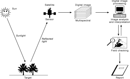
This is part of a larger scene imaged by the Thematic Mapper (TM) sensor on the Landsat 5 satellite.
The date of the image is 1st August 1990.
The black box shows the location of the study area.
The white line shows the western boundary of the Peak District National Park.
To learn more about satellite images, visit the Canadian Centre for Remote Sensing Tutorial
Bands
- The Thematic Mapper (TM) sensor is a multispectral sensor.
- It acquires seven digital images simultaneously, known as bands.
- The bands record the sunlight reflected from the Earth and the heat emitted.
- There are six light bands and one heat band on the TM sensor:
| Band | Wavelength recorded | Spectrum |
|---|---|---|
| TM 1 | Blue Light | Visible Light |
| TM 2 | Green Light | |
| TM 3 | Red Light | |
| TM 4 | Near infrared light, NIR | Invisible Light |
| TM 5 | Near-mid infrared light, NMIR | |
| TM 7 | Mid-infrared light, MIR | |
| TM 6 | Thermal Infrared (heat), TIR | Heat |
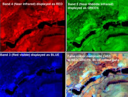
- The bands are combined to make a colour composite.
- The image above uses bands 4,5 and 3, displayed as red, green and blue respectively - shown right.
- Bands 4 and 5 are invisible light so must be assigned a false colour (red and green).
- The result is a false colour composite
Orbits
- The Landsat satellites orbit the Earth every 100 minutes.
- They image a continuous strip (or swath) of images.
- The image data is digital so it can be telemetered to ground receiving stations and stored as a series of digital images.
- Images can be purchased from NASA and other receiving stations around the world.
- Because they are digital images, they can be processed directly on a computer.
- The Landsat programme has operated continuously since 1972, with Landsat 7 being launched in 1999.
Monitoring
- The satellite reimages the same location every 16 days, allowing changes on the Earth's surface to be monitored.
- One drawback is that, of the 23 images a year for the Dark Peak, only about 3 or 4 will be usable because the TM sensor cannot see through cloud.
Applications
- Changing patterns of land cover, water quality and sea surface temperature can be monitored using a time series of images.
- The extent of the Longdendale reservoirs, the spread of towns and changes in vegetation patterns and habitats can be mapped.
- Applications for areas like the Dark Peak could include:
- Bracken encroachment.
- Policing of subsidies for managing semi-natural grassland in the Dark Peak Environmentally Sensitive Area (ESA).
- Grassland which has had fertiliser applied to improve the pasture would be a deeper orange on the false colour composite.
- The desired semi-natural grassland is a lighter yellow colour.
- The biomass of fields can also be estimated.
- Heather moor management.
- Grouse require both young and old heather which is controlled by burning.
- The colour of heather on the false colour composite changes with its age.
- A map of heather age can therefore be produced from the satellite image, assisting heather management.
- Other applications require images with smaller pixels or more and narrower bands.
- Landsat's TM pixels are 30 x 30m, so very small features cannot be mapped with these images.
- Airborne sensors such as HyMap with 3m pixels and 126 bands are being used to map peat erosion patterns, peat composition and habitat diversity.
Other Satellite Images
Many other types of satellite image are available. Visit the NERC Earth Observation Data Centre (NEODC) and NASA websites to find out more.
Learn more about fundamentals of remote sensing from the Canada Centre for Remote Sensing tutorial.
Landmap, based at Manchester, has an archive of satellite and airborne data which is free to Universities. It also has online tutorials for common image processing software like Idrisi and Erdas.