SLOPE5 FIELD SEASON 1 REPORT - SPRING 2020
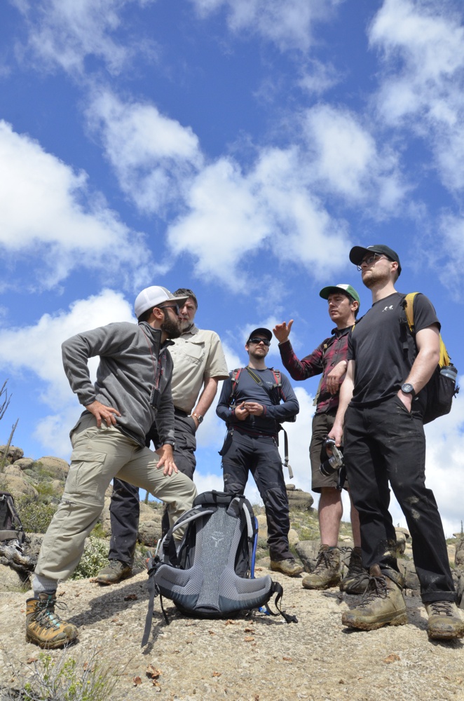
Team
University of Manchester
Prof. Stephen Flint
Dr. Ian Kane
Dr. Euan Soutter
Max Bouwmeester
University of Leeds
William Taylor
Prof. David Hodgson (in absentia)
Dr. Adam McArthur (in absentia)
University of Oslo
Dr. Miquel Poyatos-More
Details
Originally planned field dates: 10 March - 10 April 2020
Field dates: 10-20 March 2020
Reconnaissance days: 5
Data collection days: 5
Stratigraphy logged at cm-scale: 100 m
Stratigraphy logged at mm-scale: 8.3 m (683 beds)
Overview
The aim of the first field season was to begin work on work packages 1 and 2; to analyse up dip stratigraphic traps of the Rosario Formation within the Alisitos Formation in Canyon San Fernando, and to map out the facies and architecture of the Cretaceous Punta Baja Formation to be able to critically test the Karoo models from previous SLOPE project phases.
Despite the impact of Covid-19 and the subsequent shortening of the field season, we focussed on collecting enough data in the short time we had to provide a solid foundation for future research in this area. To view the data collected and initial interpretations, please see the "Current Research" section. So far, we have:
- Walked out the Punta Baja field area and identified key outcrops for future logging.
- Started logging the axis to margin sections on the beach at the end of the peninsula, correlating them and beginning to interpret the processes and architecture.
- Started logging the margin thin beds in downdip and across-strike correlations to look for thinning/thickening trends (See Punta Baja: Margin for data).
- Started walking out the laterally continuous thicker beds in the margin and mapping their distribution.
Mitigating Circumstances
Our arrival in Baja California was accompanied with unusual weather conditions for a desert climate region. Sustained heavy rainfall rendered most dirt roads treacherous or inaccessible. Even as the rains cleared, delayed river surges caused unexpected upholds at crossings. The access road to the Mesa San Carlos was largely washed away and was not repaired in time for the planned reconnaissance. A one-day reconnaissance to the up-dip pinch-out of Canyon San Fernando was successful however. Once the dirt track to Punta Baja proved safe, we established a base camp in the local fishing village, and the first part of our campaign focussed on reconnaissance and data collection on the peninsula.
The first travel restrictions related to the surge of the Covid-19 pandemic prevented part of the field team from travelling to Mexico. In a matter of days, the entire team was recalled which ended the field campaign with only 10 out of the planned 30 days completed.
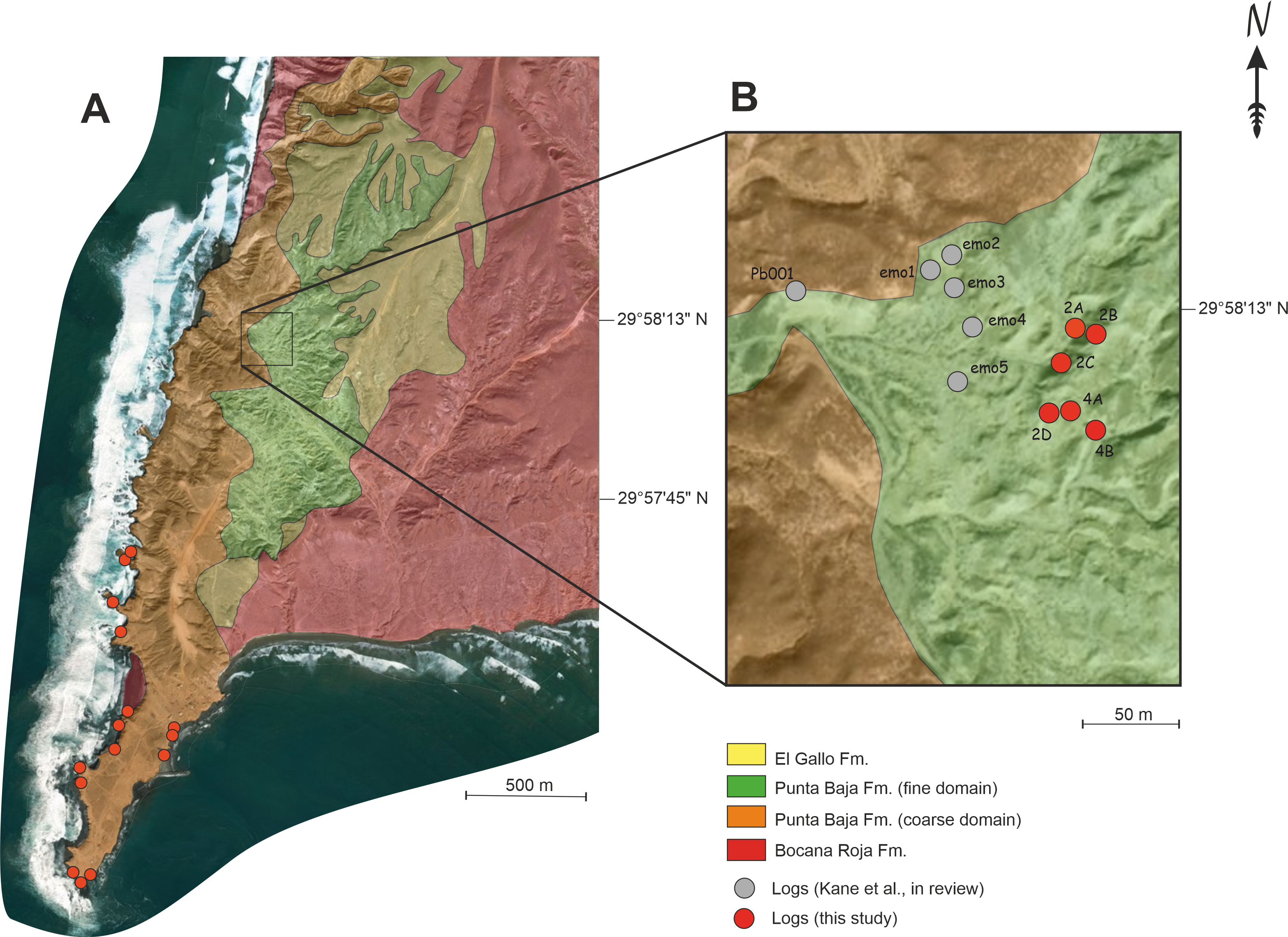
Canyon Punta Baja Reconnaissance
The below sections highlight a few key areas and observations made which will be revisited in detail in subsequent field seasons.
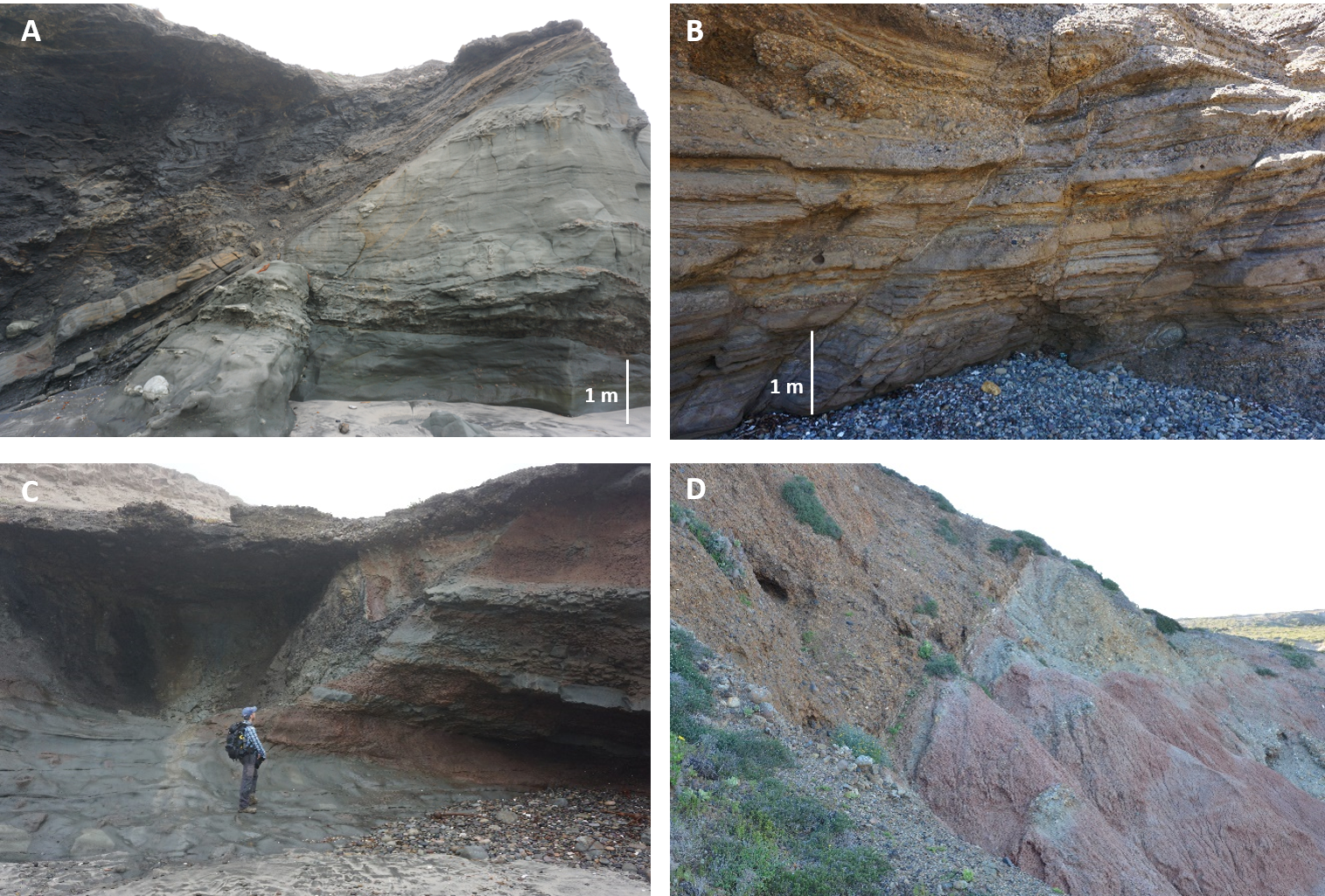
Canyon wall/Axis Strata
Reconnaissance on the Punta Baja Peninsula included the canyon wall and erosional contact with the Bocana Roja Fm. on the eastern and western side of the Peninsula.
A. The Bocana Roja Fm. is more heavily faulted and tilted than the Punta Baja Fm. Its faults are mainly compressional in the east and extensional in the west of the peninsula.
B. Minor faults occur in the Punta Baja Formation. The timing of faulting and whether this influenced sedimentation patterns in the canyon is part of future work.
C. Small scale channel cut and fill of the Punta Baja Fm. into the Bocana Roja Fm., with in the upper right a relatively intact wedge-shaped block of substrate entrained in the channel fill. Such clasts and smaller seem common in the lower parts of the Punta Baja channel fills, near the canyon wall.
D. A large ENE-WSW trending normal fault causes a steep tectonic contact between the Bocana Roja (right) and the Punta Baja canyon fill (left). Whether and when this fault was active during sedimentation, and its influence on sedimentation patterns and even canyon morphology, is part of ongoing investigation.
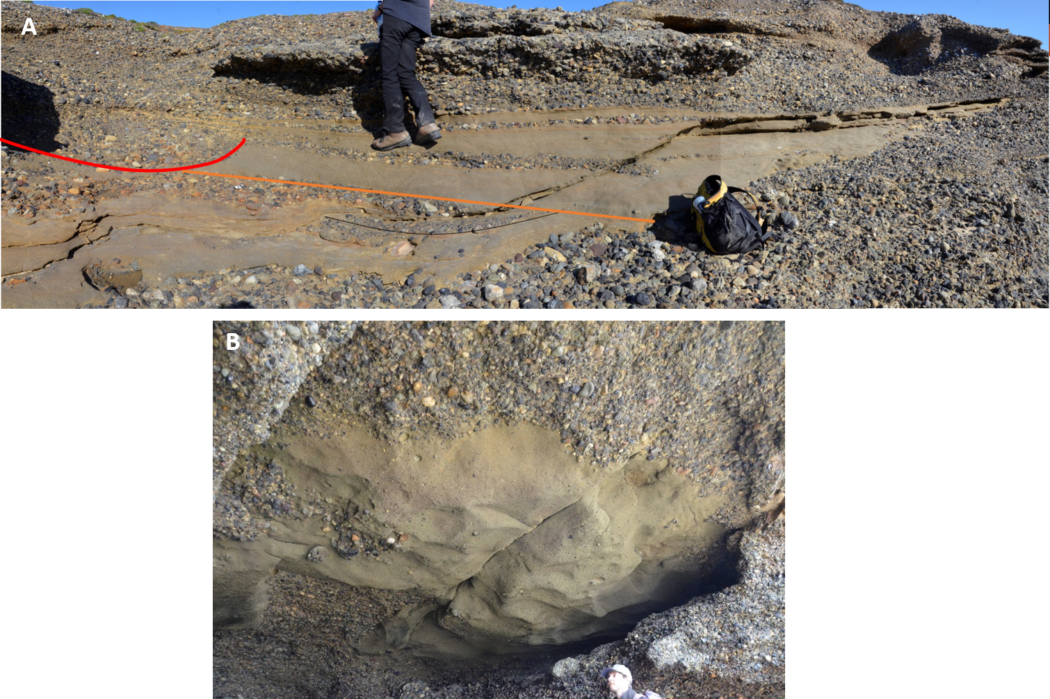
Scours
Metre-scale scour fills are common in the axis. The erosion surface is usually steep and the fill seems to record multiple cycles of cut and fill, and even upstream migration patterns. Scour structures in submarine channels have become a major research topic in recent years, observed on centimetre to kilometre scales in ancient and modern systems. They may represent hydraulic jumps, and their relation to supercritical flow conditions may improve our understanding on sediment transport and deposition in these systems.
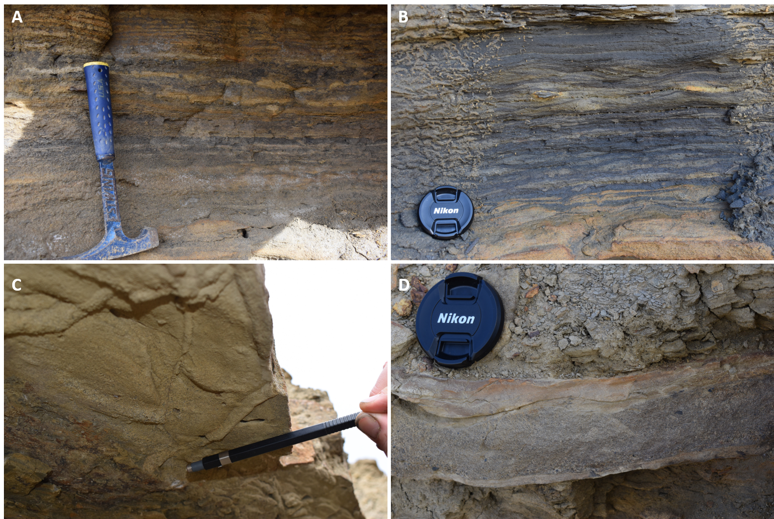
Channel-belt margin
The margin is characterised by millimetre-scale thin-bedded sediments, although centimetre-scale sand beds of up to coarse sand are common. The lateral extent and thickness of these beds can be variable and will be a major part of future analyses. If, and how these beds prove to be connected to the canyon axis may cause a complex distribution of petroleum and may act as leakage points. Some of these beds display complex structures that pinch and swell, that upon first inspection seem to be three-dimensional and resembling Hummocky Cross Stratification (HCS). The related sedimentary processes may provide information on water depth and hydrodynamic conditions. Understanding their distribution may prove important in estimating reservoir properties in other systems worldwide.
Can San Fernando Reconnaissance
Up-dip Pinchouts
This work aims to examine the relationship of the Rosario Fm., with its long-lived entry point to the slope through a carbonate succession, within the Alisitos Fm. The up-dip pinch-outs are well exposed with 3-D control for several of the Rosario systems but have never been worked. They offer a world class example of up-dip pinchout with complex geometries and multi-component histories. Work will include mapping, sedimentary logging and tracing out complex geometries, with extensive use of UAV-based models. The below photos highlight some key observations of the up-dip study area.
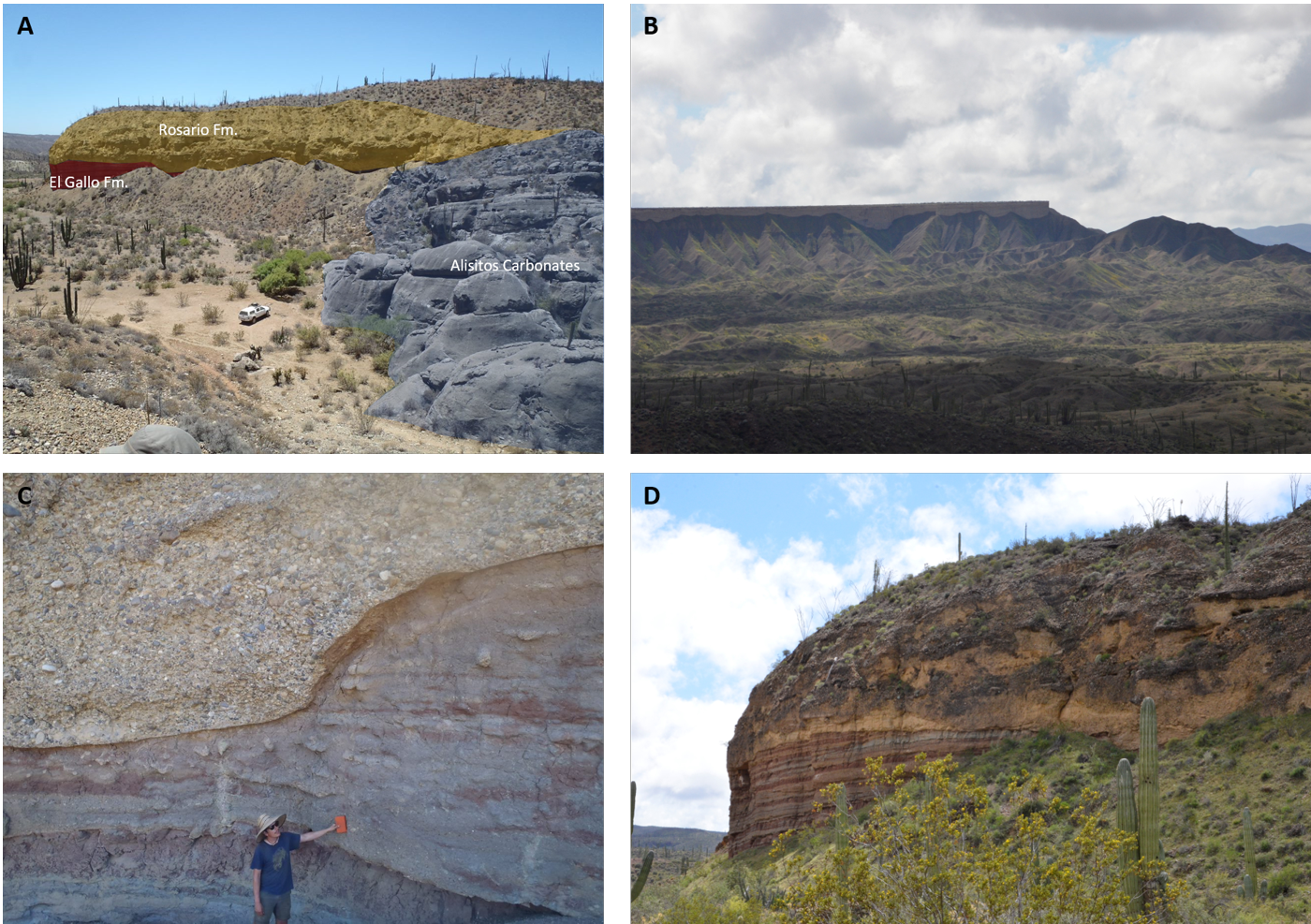
A. View to the north-east. The Alisitios Fm. limestones form the topography in the right side of the photo. This carbonate platform is probably an example of persistent topography, formed as the rim of the shelf to north, dividing it from the slope to the south and acting as a initial sediment barrier. The orange-brown coloured sediments in the center-left of the photo represent fluvial-continental facies that once likely filled the present-day topographic depression. The grey slight topography in the center-right is the northernmost extent of the Rosario Fm. (s.s.) and represents the onlap of deep-water canyon-filling sediments on the canyon head. We speculate that this canyon head migrated shelf-ward, eroding part of the Alisitos limestone (to the right) to allow passage of sediment from the shelf into the submarine canyon. The conditions of canyon head formation are unknown, and future study should allow us to compare this system to modern canyon systems. This exceptionally preserved section allows for development of models for up-dip pinch-outs in similar systems worldwide, since they are mostly below seismic resolution but can act as an important reservoir leakage point.
B. View towards the Mesa San Carlos.
C. South of the Alisitos shelf-rim. The erosional contact between the El Gallo Fm. continental fine-grained paleosol sediments (brown-red-grey) in the lower left of the picture, and the Rosario coarse-grained canyon fill in the upper part of the picture. The erosional surface forms capricious relief, and is likely the composite surface of multiple erosive channels.
D. Erosional contact between the Rosario Fm. (above) and the El Gallo Fm. (below).