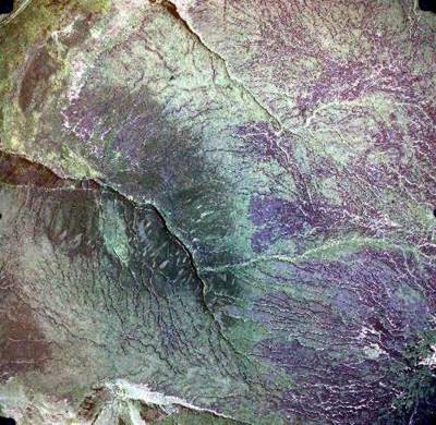
This is the full aerial photo from which the extract of the Y-lobe was taken

1998 image courtesy of ADAS MAFF (now DEFRA). Image shows true colours
- You can see the Y-Lobe location at the southern end of Sykes Moor, overlooking Torside Clough.
- There are other areas of exposed peat to the north, shown as deep purple.
- The peat to the south, between Wildboar Grain and Bleaklow Head is a lighter tone because it was burned in an accidental recent fire
- Today this area is a mixture of burned root mat, regenerating bilberry and peat exposed in gullies.
- Gullies draining from the peat can be seen as white lines.
The aerial photo gives a good overview of the vegetation patterns.
- Notice the dark green v-shaped area in Torside Clough - this is heather moorland. The lighter patches within it are areas deliberately burned for grouse.
- The brighter green in the top left (NW), beyond Long Gutter Edge is Molina (Purple Moor-grass) and bracken on the lower, better drained ground.
We'll learn more about these vegetation patterns later...