FRCA (now Rural Development Service of DEFRA)
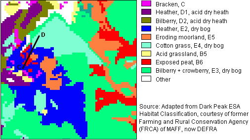
Habitat Map © of Sykes Moor

This habitat map was produced by fieldwork and visual interpretation of aerial photographs, like the ones used in the virtual tour
- Boundaries between habitats were mapped manually and then digitised so that the digital map can be displayed on a computer screen.
- It's blocky appearance is due to the method used to convert it into an image - the original boundaries were much smoother.
Differences between Habitat Map and HyMap vegetation maps
- Every pixel can be classified on HyMap so that patches down to 3 x 3m are mapped. It is not necessary or possible to manually map such small patches for the habitat map, e.g. 'Eroding moorland' is used for complex areas with a dense network of exposed peat and gullies with 10-75% vegetation cover.
- The habitat map divides heather and bilberry each into two classes according to the depth of peat below (see the vegetation theme pages for more details).