Slope geomorphological modelling

Computer-generated images of submarine slope landscapes can appear visually similar to their subaerial counterparts. Closer examination reveals that they have similar topographic characteristics in a quantitative sense also.

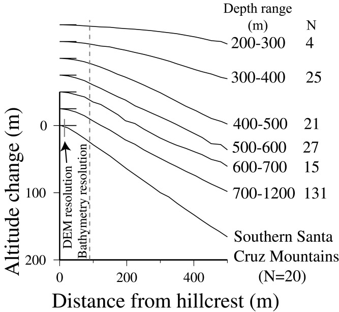
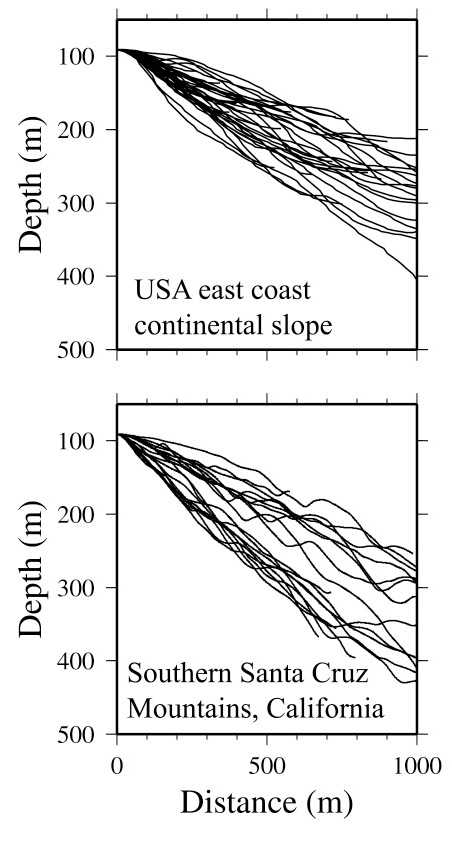
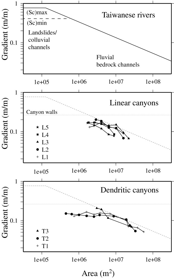
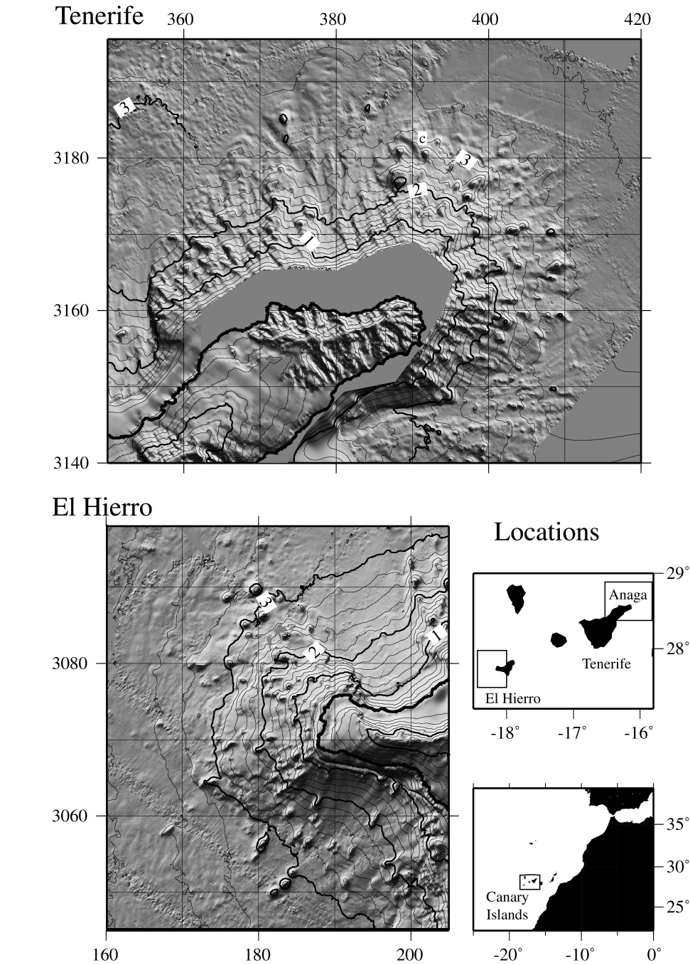
The following pages show how submarine hillsides can have similar "threshold" slopes to those found on land, how submarine canyons can have analogous variations between canyon catchment area and channel slope to those of rivers, and how smooth "diffusional" landscapes can also be found in these two different environments.

Developing "quantitative geomorphology" under water is hampered by the inaccessibility of these areas and a lack of techniques (erosion rates cannot be quantified by cosmogenic radionuclide dating, for example, because seawater rapidly absorbs cosmic radiation). This work instead explores geometrical analogies between submarine and subaerial geomorphic systems. Although the sedimentary processes causing these analogous characteristics are different, the similarity suggests that we might look for mathematical similarity in the outcomes of geomorphic processes. That in turn should guide efforts in collecting new datasets and in developing new techniques to quantify geomorphic processes.

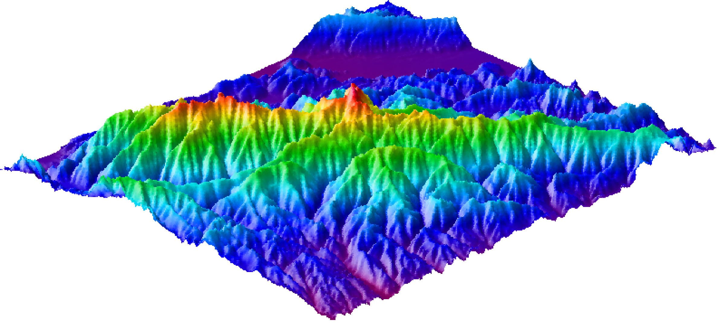
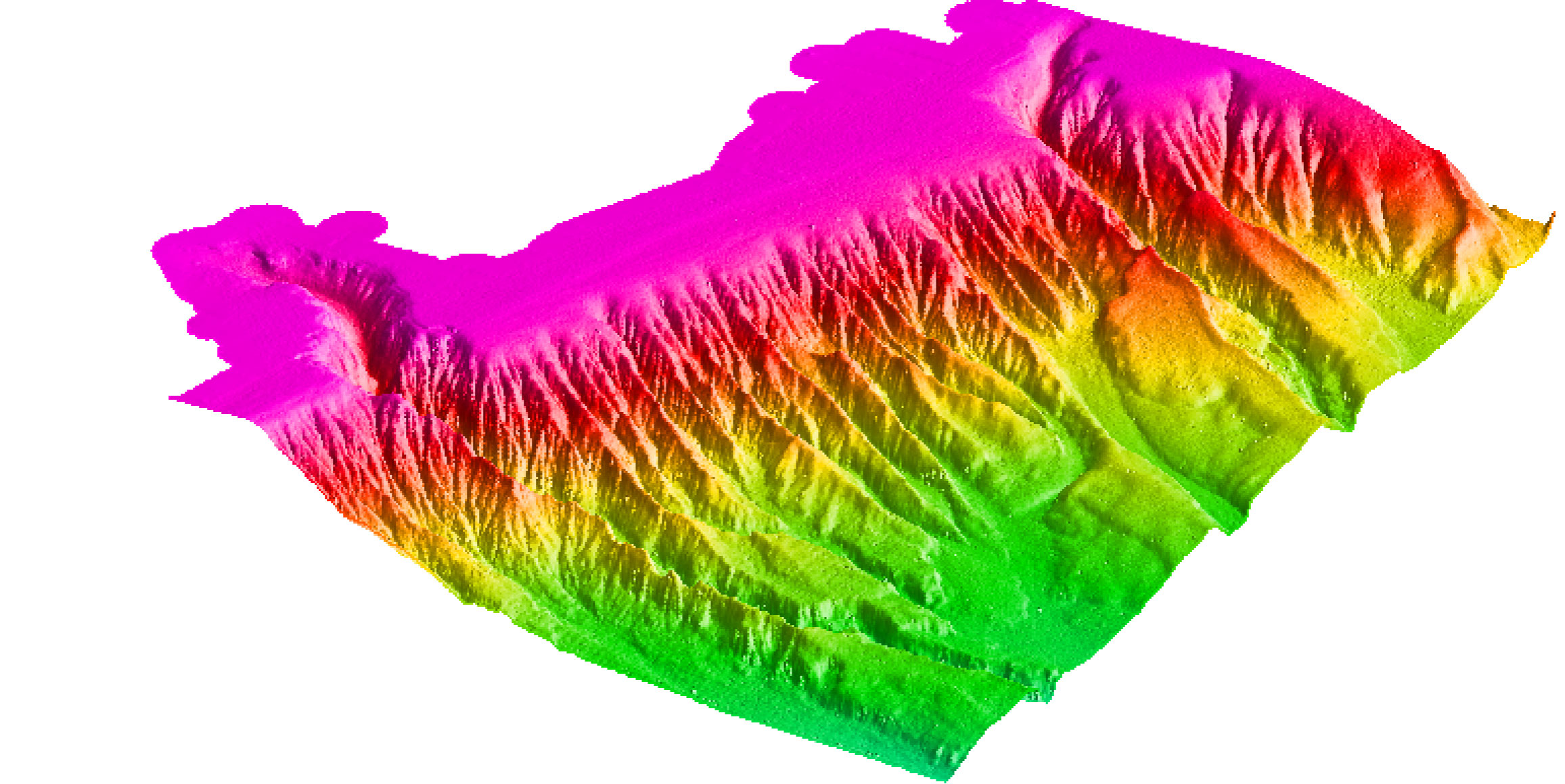
The figure above shows a computer-generated image of the Southern Santa Cruz Mountains of California, an area uplifted by motion along the San Andreas fault system. Notice that the range has sharp (angular) hillcrests and the hillsides are relatively straight, not rounded. These are typical attributes of rapidly uplifting tectonic landscapes. (DEM data courtesy of the US Geological Survey.)

The figure on the left shows a portion of the USA east coast continental slope and shelf break (the two large canyons seen incising the shelf are Norfolk and Washington canyons and water depth ranges from 60 m to below 2000 m). Notice that the incised continental slope has hillcrests (inter-canyon divides) that are also sharp and angular. In contrast, the landscape at the shelf break (pink regions) is smooth and analogous to diffusional landscapes in subaerial lowlands. (Data collected with multibeam sonars and distributed by the NOAA - "Coastal Relief Model" www.ngdc.noaa.gov/mgg.)

Threshold hillslopes

In many mountain landscapes, frequent surficial landsliding causes hillslopes to develop simple linear profiles, with gradients reflecting their limits of stability in extreme conditions of high rainfall or during seismic ground shaking. The graph on the lower right shows a series of profiles across the range divide derived from a USGS DEM (profiles are aligned with the summit of each hillslope mimicking a graph of RS Anderson (1994)). The upper graph shows a set of profiles calculated for the USA east coast continental slope (taken across inter-canyon ridges), showing a similar diversity of forms. The graph below shows averages of these profiles, revealing that, once the variability is removed by averaging, topography in both environments has linear "threshold" hillslopes. Thus the seabed morphology in these regions is sculpted by frequent surficial landslides and new accumulations of sediment are likely to be unstable, as frequently observed in core samples and from submersible.

Canyon erosion - analogy with subaerial fluvial and colluvial systems

The graphs on the right compare the relationship between channel gradient and rainfall catchment area for mountain rivers in Taiwan (based on data published by K Whipple) with similar graphs calculated for the continental slope canyons, deriving catchment area in the same way as with river drainage basins. Surprisingly the two sets of data can show a comparable relationship (graph slope) between gradient and area. The submarine data however tend to show a greater diversity of forms. In these examples (from the Virginia slope), the graphs tend to curve below A<10^7 m^2. This project aims to resolve the origin of this relationship, drawing analogies with erosion of river systems. For further information see these pages on modelling submarine canyon development by erosion.

Rates of submarine erosion

Rates of erosion (exhumation) are difficult to ascertain because the material representing the erosion history is usually absent or difficult to relate to the erosional terrain. There are tools in subaerial geomorphology to address this issue, such as cosmogenic radionuclide dating of exposed surfaces, fission-track and He dating, other dating of strath surfaces and terraces, and sediment budgets. In the submarine landscapes, these tools are mostly not available or at least difficult to apply. This project made a first attempt using submarine slopes of volcanoes in the Canary islands, where the different ages of the volcanoes provide a chronology. We found that the greater depth of incision around Tenerife compared with El Hierro (a younger volcanic island) was compatible with the slow denudation rates seen in subaerial lowland landscapes. Rates are larger than found in the deep sea but smaller than subaerial tectonically active landscapes. For further information see: abstract and full article (PDF)*.

The figure on the right shows the morphology of northeast Tenerife (Anaga) and western El Hierro derived from multibeam sonar data. The technique explained in the article quantifies the difference in ruggedness of the submarine slopes, the older slope of Tenerife showing many gullies and canyons.

Smoothing of submarine landscapes

Many incised continental slopes have smooth parabolic-like interfluves between channels. For example, the above example of the USA east coast continental slope shows rounded interfluves to 400 m depth, below which the interfluves are sharp. These morphological characteristics are interpreted to represent the product of two classes of surface modification processes which oppose each other, leading to either rough or smooth topography depending on their relative importance. One set involves sediment movements or varied deposition which smoothes the sediment surface. Another set incises the sediment surface or leaves sharp topography, such as channelled erosion by gravity flows and landsliding. The transition with depth from smooth to sharp interfluves for the mid-Atlantic slope then reflects a decline in smoothing and/or an increased rate of incision.

To explain this, we are exploring a mathematical analogy with the smoothing effects of soil creep on subaerial hillslopes. Although creep seems unlikely to explain diffusive-like morphologies in submarine environments, the gravity effect on saltating sand under oscillating currents could potentially lead to down-slope movements with fluxes proportional to local bed gradient as required by diffusion models. Some of this work is in collaboration with the Proudman Oceanographic Laboratory. abstract

See also:
Accumulation of sediment deposits around mid-ocean ridges, which includes geomorphological modelling (diffusion) of sediment surfaces and quantifying the spatial distribution of deposition,
Quantifying rock slope geomorphology of mid-ocean ridge escarpments based on observations made from submersible dives. This work examined the gradients of different lithologies and found a significantly smaller maximum gradient for serpentinite, which may relate to serpentinite's unusual bulk rock properties. The study also looked at the geometries of talus fans and speculated on their relation to tectonic history.

Relevant publications

Funding for this work was provided by a Research Fellowship from the Royal Society. The data around the Canary Islands was collected with NERC funding to DG Masson and AB Watts.

Collaborators and advisors on aspects of this work have included Brian Dade (Dartmouth, NH), Doug Masson (SOC, Southampton, UK), John Huthnance (Proudman Oceanographic Lab, Liverpool) and Lucy Ramsay and Niels Hovius (Cambridge).

*The American Geophysical Union owns the copyright to this document. Further reproduction or electronic distribution of them is not permitted.


Return to Neil Mitchell home page