Sedimentation on mid-ocean ridges
The sediments accumulating on and around mid-ocean ridges are mostly formed from
the calcareous and siliceous tests of pelagic organisms. This research is
concerned with understanding how the rate of sediment supply varies from
place to place due to varied productivity of pelagic organisms, how the
sediments accumulate on the complex topography of a mid-ocean ridge, and
with using the sediments to study mid-ocean ridge processes such as
faulting and volcanism.
Sediment transport and accumulation
When pelagic materials reach the seafloor, they are redistributed by bottom
currents and by sedimentary flows. This work studied the form of the
accumulation using sediment profiler records collected with a Deep Tow
system from the Scripps Institution of Oceanography deployed over the
Mid-Atlantic Ridge in the early 1970s.
The records showed that both sets of transport processes are important.
The shapes of deposits were studied
to see to what extent they conform to the diffusion transport model -
many deposits have parabolic surfaces, which are the steady state forms
expected from the diffusion transport model under boundary conditions
of constant input or output flux to basins. (Abstract and full article (PDF)*.)
In a second study, profiler records from the Galapagos spreading centre were used to
assess sediment transport rates. The method essentially involved
quantifying the amount of material eroded from (or not deposited on) the
crests of fault scarps, and dividing this value by the age of the scarp which
is well known from the seafloor spreading history. Due to the method used,
the result was an upper bound on rates of surficial sediment movement. (Abstract and full article (PDF)*.)
Accumulation rates
Sediment on ridge flanks commonly thicken with distance from the spreading
axes, reflecting the increasing age of the volcanic seafloor. Complications
to this simple picture occur where there is substantial sediment transport or
varied dissolution of carbonate. High resolution
sediment profiler records collected on the Mid-Atlantic Ridge in 1996 (CD99) show that this simple picture is
not applicable there, which has implications for attempting to use the
thickness of the sediment cover as a dating tool on slow-spreading ridges
(abstract.). However,
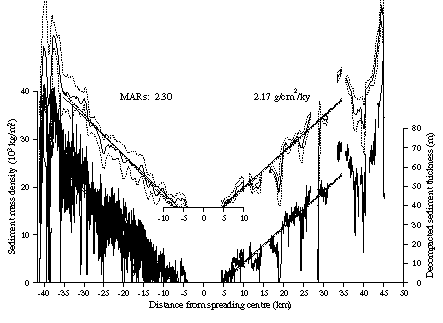
sediments on the Galapagos spreading centre (figure right) do show a simple systematic
trend, partly because the ridge lies beneath the equatorial zone of high
pelagic productivity causing very high accumulation rates relative to rates of sediment
redistribution and dissolution. Accumulation rates are higher on the south flank, closest to the centre
of the high productivity zone.
Abstract.
|
|
|
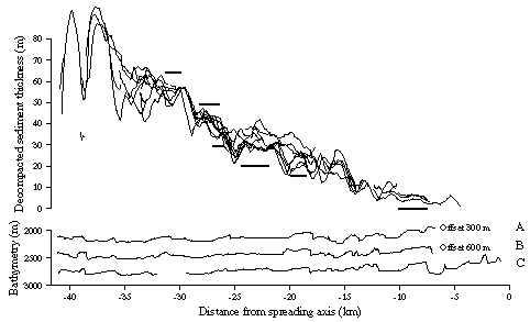
Mapping lava flows
Due to the high accumulation rates on the Galapagos spreading centre
relative to sediment redistribution rates, the thickness of sediment
is a useful proxy for seafloor age. The ridge flanks have areas of
near uniform sediment thickness which correspond to flat basement topography and
are bounded by fault scarps. These areas are highlighted by horizontal bars in
the figure (left) and were interpreted as regions of uniform age due to large lava
flows. As a consequence of the flows, the surficial oceanic crust is
slightly younger than might be predicted by simple seafloor spreading and distance of the seafloor from the ridge axis.
Hence the sediment does not thicken monotonically away from the ridge axis
but begins to thicken from a point away from it (e.g., as shown in the
figure (above), from around 5 km). Using these sediment thickness data,
the crustal age anomaly was estimated to be
approximately 120-150 ky for the Galapagos spreading centre.
Abstract
|
See also work on sonar penetration
into marine sediment and the possible use of variations in backscatter to
infer variations in the sediment cover over young seafloor.
Relevant publications
Funding for the above work was provided by Research Fellowships
from the Royal Society and the NERC. This research was primarily based
on data collected with the Deep Tow system of Scripps Institution of Oceanography.
*The American Geophysical Union owns the copyright to these documents. Further reproduction or electronic distribution of them is not permitted.
Return to Neil Mitchell home page