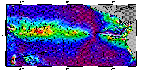
Sediment thickness from an NGDC database (red, ~600 m thick).
Modelling the sediment distributionThick accumulations of calcareous and siliceous ooze occur in the central Pacific due to high productivity of pelagic organisms associated with oceanic upwelling along the equator. West of 100 deg W, these have deposited on the Pacific plate and, due to the northward component of the plate's drift, the thickest accumulations are displaced north of the equator. This study simulated the sediment distribution using information from Deep Sea Drilling Project (DSDP) cores and models for Pacific plate motion. The DSDP cores provided data on how mass accumulation rates have varied over time and on the form of enhancement around the equator. Varied dissolution with depth was also accounted for using published trends in dissolution rates derived from the DSDP cores and paleodepths from a new subsidence calculation. A westerly deepening of the carbonate compensation depth (CCD) and a sedimentary lysocline evolution were proposed, which improved the model for seafloor 30 Ma and older. The following were the two main outcomes of this research:Mantle dynamics and dissolution The basement and present bathymetry in the central Pacific show a broad-scale deepening towards the north, which is ultimately caused by density differences in the Earth's mantle. The sediment bulge is distorted by increasing dissolution to the north across this bathymetric gradient, and hence there is an interesting connection in this area between mantle geodynamic processes which distort the Earth's surface and the sedimentary deposition. Testing models of plate motion The degree of match between model and data for 35-40 Ma seafloor was used as a test of models for Pacific plate motion relative to the equator. Since the motion of the Pacific plate relative to the earth's mantle is relatively well known from hot-spot trails, this test turns out to be useful for testing true polar wander (TPW, motion of the hot-spot frame relative to the earth's spin axis). Results favor TPW models which have little or no effect on the central Pacific paleoequator over the period 30 Ma to recent. (Abstract and full article (PDF)*.) |
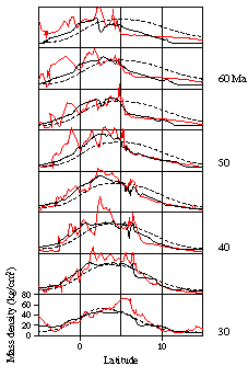
N-S cross-sections of sediment thickness data (black lines), and models accounting for carbonate dissolution (red) and without dissolution (dashed), showing the distortion caused by the bathymetry. |
 The stratigraphy of the equatorial Pacific sediments reflects the combined effects of Pacific tectonic plate
motion, carbonate dissolution, erosion by bottom currents and productivity.
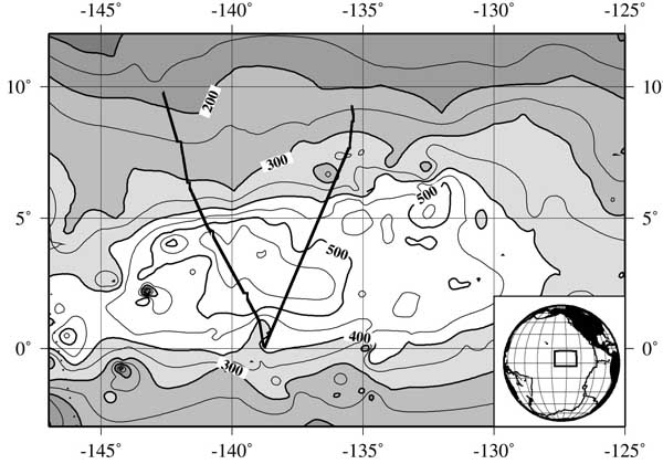
This second study examined stratigraphy derived
from seismic reflection data. Dissolution events caused by large-scale paleoceanographic
reorganizations have left discrete density anomalies in these sediments, which produce
characteristic reflectors in seismic images. This enabled the stratigraphy from two seismic lines crossing the sediment
bulge to be mapped out and analyzed.
The stratigraphy of the equatorial Pacific sediments reflects the combined effects of Pacific tectonic plate
motion, carbonate dissolution, erosion by bottom currents and productivity.
This second study examined stratigraphy derived
from seismic reflection data. Dissolution events caused by large-scale paleoceanographic
reorganizations have left discrete density anomalies in these sediments, which produce
characteristic reflectors in seismic images. This enabled the stratigraphy from two seismic lines crossing the sediment
bulge to be mapped out and analyzed.
|
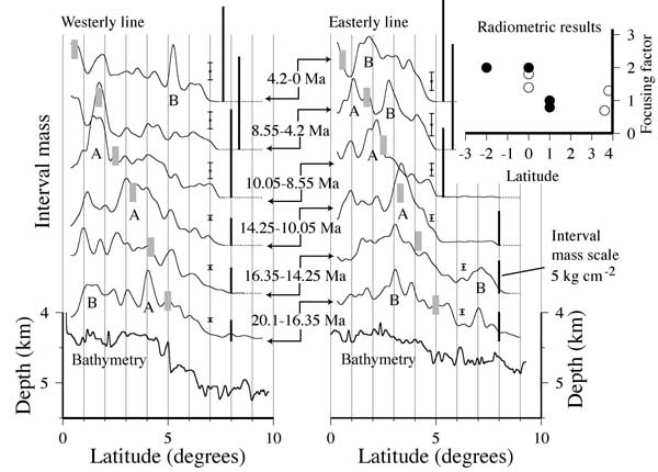
| The spacing of seismic reflectors was used to work out the intervals of sediment (dry) mass per unit seafloor area, shown on the left here versus latitude. Although these sediments are pelagic and might be expected to drape the underlying basement, accumulation can vary a great deal spatially. Consequently, accumulation rates derived from single drill cores are highly unrepresentative of regional fluxes to the seabed. We used these data to address an issue of "focusing", whereby particles have been proposed to migrate towards the equator before depositing. This suggestion was based on Th-230 deposition rates being higher than expected from the rate at which the isotope is created by radioactive decay of Uranium in the overlying water (hence the "focusing factors" in the upper-right graph). We found that there is no consistent equatorial anomaly in the seismic data. Excess Th-230 might be found fortuitously given the variability of the pattern of deposition rates. |
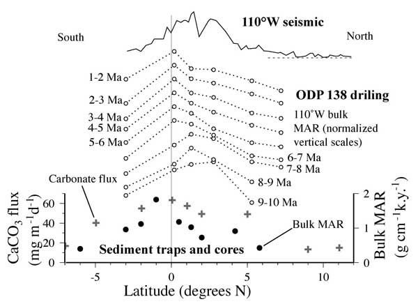
| By looking at indicators of the pattern of primary input, we inferred that the patchiness in the previous figure is probably caused by carbonate dissolution rather than varied production. Plus symbols in lower graph (left) show the broad pattern of carbonate particles recovered from sediment traps. The overlying graphs show the deposition pattern in drill cores and seismic from 110W, where the seafloor is shallower and hence the carbonates are less dissolved. All these data show a relatively broad and generally smoothly varying pattern of deposition, quite unlike that in the earlier graphs. For further information, see the abstract and full article (PDF)*. |
|
| |
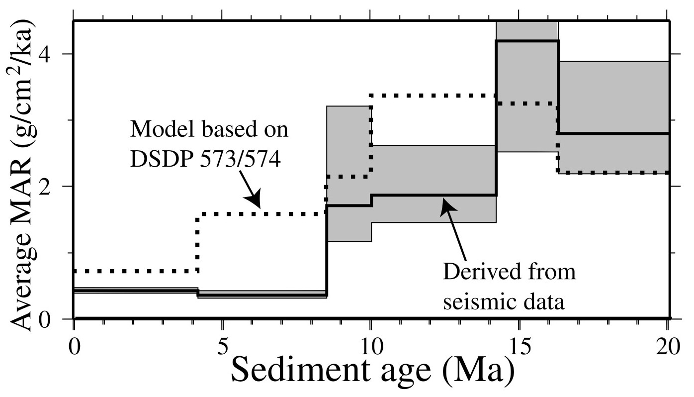
Mean bulk mass accumulation rate of the central equatorial Pacific obtained by averaging sediment mass over the region 0 to 5 degrees north and dividing between the ages of the associated seismic reflectors. 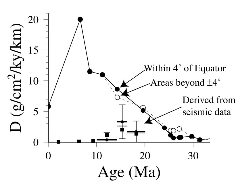
Rate of change of carbonate mass accumulation rates with depth derived from DSDP core data and from the seismic data (solid squares with error bars). |
Spatially averaged accumulation rates Erosion and non-deposition caused by bottom water flow and chemistry results in a spatially varied depositional record. Traditional methods of analysing depositional fluxes from DSDP and ODP drill core data are therefore likely to lead to inaccurate paleoceanographic inferences. In the graph (left) we demonstrated this by comparing the mean bulk accumulation rate for the central Pacific at 135-140 deg W with that produced by our numerical model which essentially extrapolates accumulation rates from DSDP Sites 573 and 574. The drill site data clearly over-represent the accumulation because drilling was located in areas of locally enhanced deposition. Such data therefore need to be corrected for bias associated with spatial variability. Carbonate dissolution and sharpness of the lysocline Differences in deposition rate at a common latitude should reflect mostly differences in carbonate dissolution because the primary sediment input (pelagic biological productivity) is relatively uniform east-west. We used this fact to isolate the rate of change of carbonate dissolution with depth by taking the difference of carbonate mass between seismic lines. The method revealed a surprising lack of a depth effect, implying a very broad lysocline here. The second figure (left) shows the rate of change of carbonate accumulation with depth derived from cores of the south and central Pacific (Heath et al. 1977) along with our estimates from the seismic stratigraphy. We speculated that this difference could be caused by Pacific Deep Water over-riding Antarctic Bottom Water in this area. As the Pacific Deep Water is more corrosive, it may cause greater corrosion in the shallower water and hence flatten the lysocline curve. For further information, see the abstract and full article (PDF)*. |
Funding for this work was provided by Research Fellowships
from the Royal Society and the NERC. The sediment thickness database (top of page)
was provided by the NGDC (www.ngdc.noaa.gov). The seismic data for the stratigraphic
study were collected on the R/V Maurice Ewing funded by the NSF and their analysis was carried out in
collaboration with Boise State University researchers Mitch Lyle, Marie Knappenburger
and Lee Liberty. PhD student, Tom Parry, is now taking this further with new seismic
data collected on the Roger Revelle in March-April 2006.
*The American Geophysical Union or Geological Society of America owns the copyright to these documents. Further reproduction or electronic distribution of them is not permitted.
Return to Neil Mitchell home page