Coastal Geology - Banner Sand Banks
Sand in the Bristol Channel largely originates from glacial outwash and reworking of glacial deposits by waves and currents.
Thierry Schmitt and I undertook a study of how this sand is being transported around
the South Wales coasts by combined currents and waves, primarily using data from two multibeam echo-sounder surveys
and one single-channel survey. "Banner Banks" are long banks of sand that lie with one end
almost connected to the coast at headlands (hence "banner-like"). They are believed to originate
from an asymmetry in the tidal currents, which traps sand seawards of the headland.
We studied three such banks in the Bristol Channel (Helwick Sands, Nash Bank and Scarweather Sands).
The speed at which sand moves around the banks was mapped by seeing how far sand dunes
move between successive surveys, characterising an element of bedload transport.
The tidal currents cause the sand to move in opposite directions around each bank
(towards the east on the north side and to the west on the south side).
Thierry's analysis showed that the total volume moving either side was
approximately balanced on both Nash and Helwick banks, though possibly
with a small imbalance due to sand driven across the bank crests.
We concluded that wave interactions with the bed were probably important
for facilitating this transport. Waves probably also cause an unusual feature
on the crest of Helwick Sands - across the top of the bank, dunes in both our
surveys appear to cross over and connect the dunes travelling in each direction.
This suggest a rapid mobilisation of dunes, as the dunes are oriented almost
exactly parallel to the direction in which waves approach the coast.
Click on the following images to enlarge them.

|
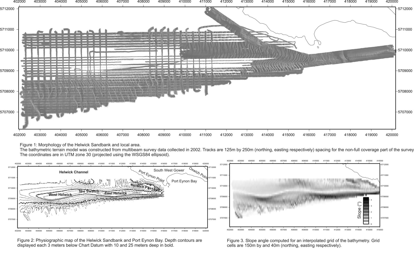
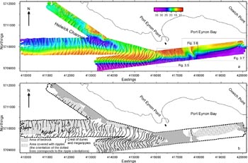
Figure 1 - View of bathymetry data collected with our multibeam sonar over Helwick Sands in 2002. This is a "shaded relief" view, simulating the effect of a sun shining on the seabed from the west (white areas are missing data). This view highlights the sand dunes on the sides of the bank. Figure 2 shows the depths contoured every 3 m. Figure 3 shows the slope angles of the bed, highlighting the asymmetry of the bank.
Over Helwick Sands, we collected three datasets: 26 September 2001 (limited to East Helwick and Port Eynon bay), 20-21 August 2002 (repeating 2001's survey and continuing to the west) and 25 May 2003 (a single-beam echo-sounder survey to allow us to see how dunes had migrated with the tidal currents).
|
|
A view of the data collected in 2002 immediately south of the Gower coastline with colour-coding for depths (see scale at top in m). This reveals the bedrock immediately south of Port Eynon Point and the dunes over Helwick Sands. Our analysis confirmed that the dunes on the north side of the bank are migrating eastwards, while those on the south side of the bank are migrating westwards. However, the dunes on the crest of the bank cross NE to SW, connecting up the dunes on the two flanks. We speculated that waves (mainly coming from the W to SW) inhance the mobility of the sand here.
|

|
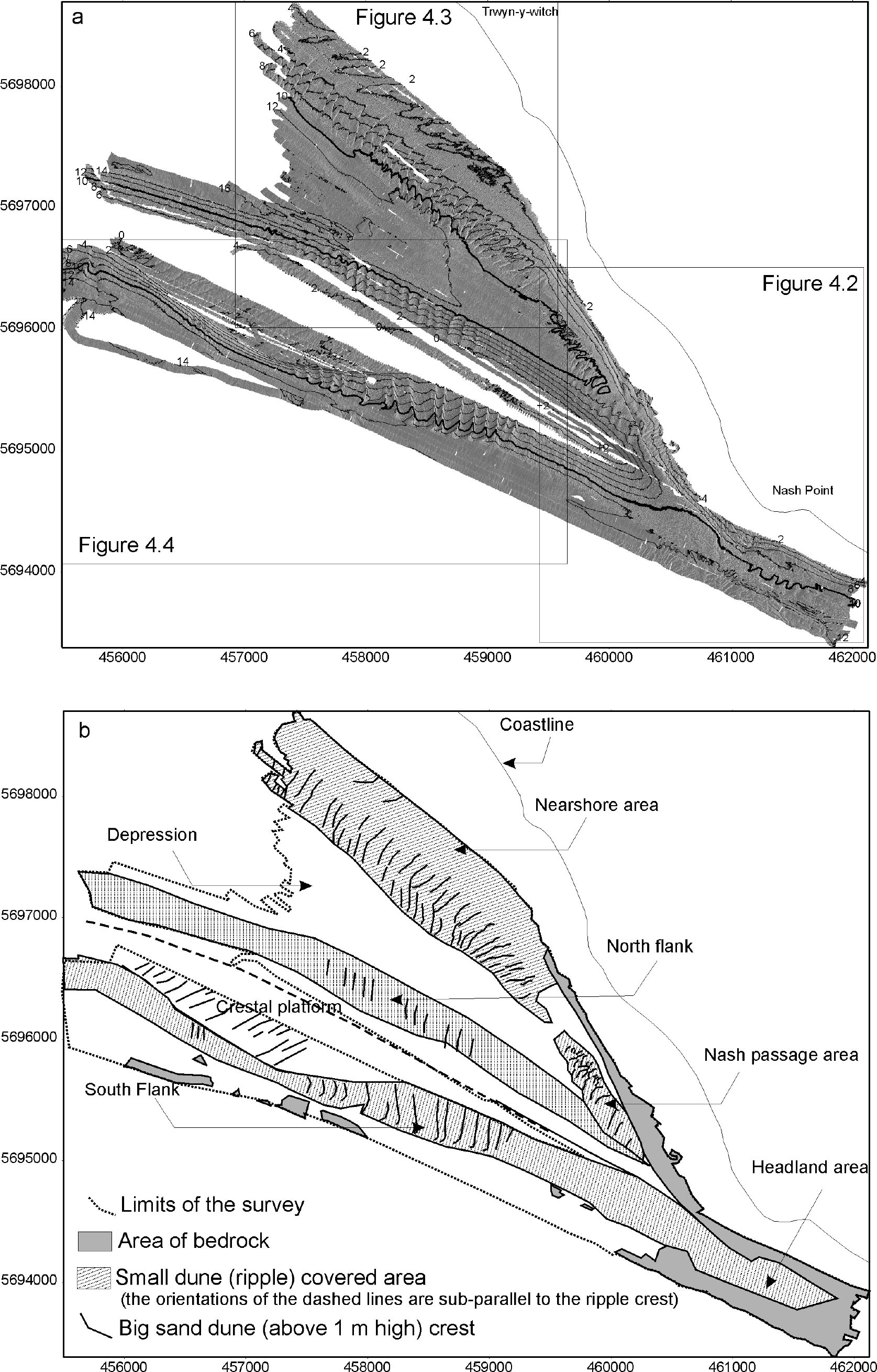
Sonar data collected in 2002 over Nash Sands and the South Glamorgan coastline (depths in m below Chart Datum are shown at ends of the contours). In contrast to Helwick Sands, Nash Sands has a flat, broad crest. Tidal currents are larger here (being further up the Bristol Channel) though wave effects for a given water depth are less intense than over Helwick Sands. Surprisingly, the transport rate of the sand is about the same on the flanks of Helwick and Nash sands as a result presumably of compensating effects of the differing wave and current conditions on the two banks.
Over Nash Sands, we collected three datasets. The main survey was carried out with the multibeam sonar on 16, 17, 19 August 2002. A second short survey was carried out on 4 September 2002 to see how the dunes had changed with the tidal currents. A final survey of 8 lines was carried out with a single beam echo-sounder on 25 May 2003.
|
Fieldwork was carried out using a portable multibeam echo-sounder installed
on local boats in 2001 and 2002
The sonar were bought on behalf of a consortium of universities (Imperial, Southampton, Leeds, Durham, Cardiff).
Go to details of the sonar equipment, and
some shots from the training course in July 2001.
Thierry is now working for the SHOM (French government hydrographic agency) working on multibeam sonar data.
Publications:
Schmitt, T, NC Mitchell and ATS Ramsay, Characterizing uncertainties for quantifying bathymetry change between time-separated multibeam echo-sounder surveys, Continental Shelf Research, 28, 1166-1176, 2008. doi:10.1016/j.csr.2008.03.001
Schmitt, T., Mitchell, N.C. and Ramsay, A.T.S., 2006. Use of swath bathymetry in the investigation of sand dune geometry and migration around a near shore 'banner' tidal sandbank. In: P.S. Balson and M.B. Collins (Editors), Coastal and shelf sediment transport, Spec. Publ. 274. Geol. Soc., Lond, pp. 53-64. doi:10.1144/GSL.SP.2007.274.01.07.
Schmitt, T., Sediment dynamics in the Bristol Channel and Severn Estuary, PhD thesis, Cardiff University, 2006. abstract.
Funding for this work came from a variety of sources, including the HEFCW (equipment), Cardiff University (PhD stipend),
the Royal Society, the NERC, Countryside Council for Wales, Hanson Aggregates, RMC Aggregates, UMD and United Utilities Green Energy Ltd. We are also grateful for data and assistance from ABP MER (Mr. Bill Cooper), Longdin and Browning Ltd., the British Oceanographic Data Centre and Llannelli Sand Dredging Ltd. (Dr. Chris Davies).
Also see work on coastal processes around the Azores volcanic islands.
Return to home page