Penetration depths of sonars and image interpretation
Sonar signals can penetrate seabed sediments so features observed in sidescan or multibeam sonar images may be buried beneath the surface. This is especially true of the low-frequency GLORIA system (6.5 kHz), which has imaged buried lava flows near Hawaii [Clague et al., 1990], buried canyon floors off the eastern USA [Schlee and Robb, 1991] and subsurface features of sedimentary fans [Gardner et al., 1991; Kenyon, 1992], but the penetration depths of higher frequency systems are still finite and may also complicate interpretation. This short note shows how published sediment attenuation measurements [Stoll, 1985] can be used with a simple acoustical model [Mitchell, 1993] to predict potential maximum penetration depths, and shows how differences in image "brightness" between targets can be used to assess their different sediment cover. As with terrestrial remote-sensing where the origins of features in images are assessed from their various brightness characteristics, it is also possible to use sonar images to assess quantitatively the seafloor terrain.
1) Penetration depth
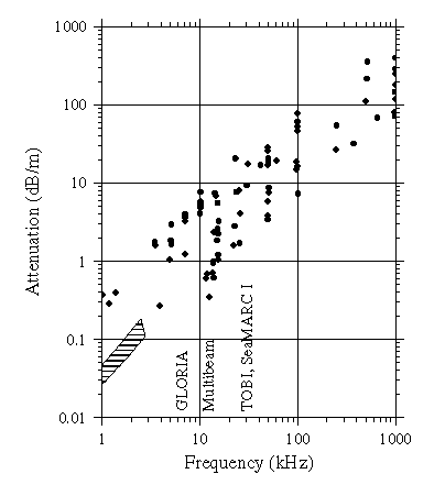
The maximum penetration depth can be estimated from the minimum attenuation coefficient at a given sonar frequency (Fig. 1). First, we simply note that the typical contrast between fine abyssal mud and bare rock is 20-30 dB and therefore a rocky surface would need to be buried by enough sediment to cause 20-30 dB of attenuation to completely blanket it. For TOBI, assuming an attenuation coefficient of 2 dB/m (Fig. 1), the signal would need to travel a total distance of 10-15 m to lose 20-30 dB. From the geometry in Fig. 2 and assuming the signal reaches the seabed at an angle (
qg) of 15deg, typical of the image centre, the rocky surface would need to be buried by 1.3-1.9 m. Repeating this calculation for other frequencies gives the range of maximum penetration depths in Table 1. These values are only maxima (most likely the systems will image much shallower than shown) and the current database of attenuation measurements is still rather weak, but this simple calculation nevertheless illustrates that it is possible to roughly assess the limits of these systems.2) Contrasting acoustical "brightness" between targets
If we find two lava flows in an image with different brightness, it would be useful to quantify what we mean by different brightness and then make a rough inference on their different burial depths, assuming that sediment attenuation is the cause. We first measure their different amplitudes in the image as A1 and A2 (the image must not of course be "histogram equalised" or otherwise adjusted), so we can calculate their contrast (DB) in decibels, 20log10(A1/A2). For the sake of argument, we assume these two flows are at the same range from the sonar so the signal will have the same grazing angle qg in both cases, which we work out from the sonar altitude and range of the target. The difference in sediment thickness is then simply:
h = DB sinqg /2a.
For example, Fig. 3 shows the decrease in backscatter away from a mid-ocean ridge observed with GLORIA. The signal drops by DB=5 dB over 10-20 km. If this were due to the increasing sediment cover [Mitchell, 1995] and since the attenuation coefficient of pelagic sediments may be as low as 0.2-0.4 dB/m at GLORIA's frequency, this signal change would correspond to an average increase in sediment thickness of 2.3-4.6 m (mean qg was 21.7deg). This estimate is very approximate given the uncertainties in the attenuation coefficients, because we cannot know for sure that the lavas have similar surface morphologies, and because there may be other acoustical effects involved in the transmission through the sediment layer, but it nevertheless provides a useful basis for discussion. During the reconnaissance stage of exploring an area, this kind of estimate may be useful to direct further work.
Table 1.
Maximum penetration depths of sonars assuming a signal loss DB of 20 dB is required to hide a buried rocky surface.
|
Frequency (kHz) |
Sonar |
Min a (dB/m) |
h (m) for q g = 45deg |
h (m) for q g = 15deg |
|
6.5 |
GLORIA |
0.2-0.4 |
18-35 |
6-13 |
|
11-15 |
Hawaii-MR1 SeaMARC II SeaBeam Simrad EM12 Hydrosweep DS |
0.4-1.0 |
7-18 |
2.6-6.5 |
|
27-30 |
TOBI, SeaMARC I |
1-3 |
2.5-7.0 |
0.9-2.6 |
|
120 |
DSL-120 |
10 |
0.7 |
0.26 |
Clague, D.A., R.T. Holcomb, J.M. Sinton, R.S. Detrick, and M.E. Torresan, Pliocene and Pleistocene alkalic flood basalts on the seafloor north of the Hawaiian islands, Earth Planet. Sci. Lett., 98, 175-191, 1990.Gardner, J.V., M.E. Field, H. Lee, B.E. Edwards, D.G. Masson, N. Kenyon, and R.B. Kidd, Ground truthing 6.5-kHz sidescan sonographs: what are we really imaging?, J. Geophys. Res., 96, 5955-5974, 1991.
Kenyon, N.H., Speculations on the Geological Causes of Backscatter Variation on GLORIA Sonographs from the Mississippi and De Soto Fans, Gulf of Mexico, Geo-Mar. Lett., 12, 24-32, 1992.
Mitchell, N.C., A model for attenuation of backscatter due to sediment accumulations and its application to determine sediment thickness with GLORIA sidescan sonar, J. Geophys. Res., 98, 22477-22493, 1993.
Mitchell, N.C., Characterising the extent of volcanism at the Galapagos Spreading Centre using Deep Tow profiler records, Earth Planet. Sci. Lett., 134, 459-472, 1995.
Schlee, J.S., and J.M. Robb, Submarine processes of the middle Atlantic continental rise based on GLORIA imagery, Geol. Soc. Am. Bull., 103, 1090-1103, 1991.
Stoll, R.D., Marine sediment acoustics, J. Acoust. Soc. Am., 77, 1789-1799, 1985.
Fig. 1. Attenuation coefficients of marine sediments from Stoll [1985]. The frequencies of various sonar systems are marked ("multibeam" refers to deep water 12-15 kHz systems).
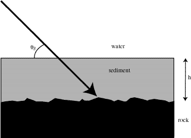
Fig. 2. Geometry of interaction of the signal with a seabed consisting of a drape of fine mud overlying a rocky surface.
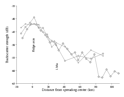
Fig. 3. Signal variation across a mid-ocean ridge [Mitchell, 1993], showing a decrease of 5 dB per 10-20 km outside the median valley, due to increasing sediment cover.
_____________________