Multibeam sonar survey of the central Azores volcanic islands

An article submitted to InterRidge News

In September-October 2003, we surveyed the central Azores islands with a portable Reson Seabat 8160 multibeam echo-sounder installed on the University of the Azores R/V Arquipelago (Figure 1). The cruise was a unique collaboration between marine geophysicists from Cardiff University, and marine biologists and geologists from the University of the Azores. Besides revealing the volcanic and tectonic structure of parts of the Azores spreading plate boundary, the data will aid the assessment of spawning grounds for pelagic fish, which form an important resource for the local economy, and will inform local authorities of geological hazards to coastal populations.

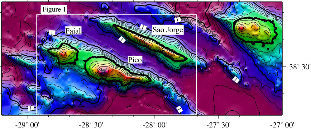
The Azores islands are often visited by scientists as they provide convenient and pleasant ports for research vessels working in the central Atlantic but they have been less a focus for marine geophysics themselves. Along with the 1999 Italian-UK AZZORRE99 TOBI deep-tow sidescan sonar survey around the central islands [Ligi et al 1999], forthcoming multibeam sonar surveying by the Portuguese STAMINA group around Terceira [N Lourenco, pers. comm.] and rock dredging from FS Poseidon [CW Devey, K Haase pers. comm.], this project represents a renewed interest in the Azores.
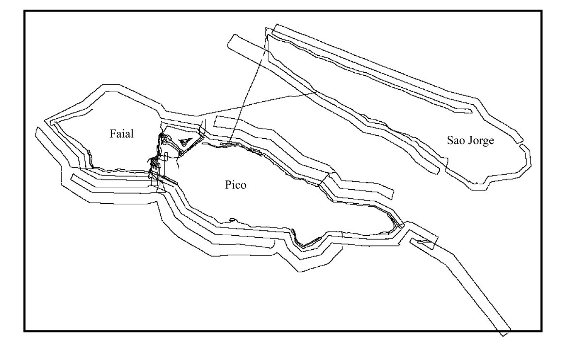
Figure 1. Survey tracks around the coasts of Faial, Pico and Sao Jorge. The system was used to map from depths as shallow as 10 m down to below 1000 m.

The Azores as an ultra-slow spreading plate boundary

There has been much recent interest in the volcanic and tectonic structure of ultra-slow spreading ridges such as the Southwest Indian Ridge and Gakkel Ridge in the Arctic, because the extreme spreading rate may potentially shed light on melting processes in the underlying mantle and delivery of melt through the lithosphere to form the oceanic crust (Mapping and Sampling the Arctic Ridges: A Project Plan, InterRidge, pp. 25, Dec. 1998). Spreading at ~3 mm/yr [Searle, 1980], the Azores region is an ultra-slow spreading plate boundary, much slower than the Gakkel Ridge (6-15 mm/yr [deMetts et al., 1990]). Volcanism is distributed sporadically across the plate boundary, creating the individual islands and interspersed submarine edifices, a result of a broad underlying melting anomaly [Bonatti, 1990]. The volcanic centres illustrated by the topography (Figure 2) show that volcanism is localized in a way that is comparable to that of Gakkel Ridge [Edwards et al., 2001]. Figure 2. Topography of the central Azores islands (contours every 200 m with bold contours annotated every 1 km). The structure forming Faial-Pico and the island of S‹o Jorge are elongated volcanic ridges, and further volcanic ridges exist among the islands. An eruption on the ridge immediately west of Terceira in particular was the subject of a previous article by Freire Luis et al. [InterRidge News, 8(1), 13-14, 1999].

The Azores as a natural laboratory of mid-ocean ridge processes

The islands and their adjacent submarine ridges reveal volcanism and tectonic features over a range of water depths and with different tectonic-volcanic configurations, which have the potential to shed light on a variety of mid-ocean ridge processes. For example, the elongated morphology of the islands of Sao Jorge and Pico-Faial and of their adjacent submarine ridges suggest that they are tectonically controlled. Sao Jorge and eastern Pico, in particular, are bisected by linear arrays of volcanic cones - studying their geometrical relationships to faults may aid understanding of how volcanism is affected by tectonics. Furthermore, the submarine ridges transcend a variety of water depths and ambient pressures. By studying the distribution of different surface morphologies of cones in these ridges over a range of water depths, it may be possible to infer if ambient pressure affects the style of volcanic extrusion. The geochemistry of rock samples dredged from Poseidon will help to reveal effects of varied lava chemistry on extrusion style, as well as spatial heterogeneity of the underlying melt source.

The Azores as a natural laboratory of volcanic ocean island processes

The Hawaiian, Canary and several other volcanic ocean islands have been imaged with multibeam sonars over the past decade (we use the term Ôocean islandÕ to distinguish these from arc islands). However, those data were collected with deep-water sonars fitted to large vessels that were unable to work in the coastal zone. The small vessel Arquipelago was able to work to very shallow water (10 m) where the unique dynamic beam focusing of the Reson Seabat 8160 sonar allowed us to image fine-scale features. As the system also functioned well in 1000 m, we were able to collect data over the whole profile of the islands, to address both deep and shallow processes during the same survey. Many issues concerning the submarine volcanic growth and modification of volcanic islands remain unresolved, and much of the existing work has been carried out on HawaiÕi, which is not representative of most oceanic volcanism. The submarine parts of volcanic islands are usually much larger than their parts above sea level but it is still unclear to what extent the submarine parts grow from direct volcanic extrusion or from material originating from above sea-level (debris from coastal lava-sea water interactions and erosion or from lava tubes transcending the surf zone [Moore et al., 1973]). The new data should help address these aspects. Furthermore, the coastal zones of the Azores contain abundant submarine terraces. Correlating them with the global sea-level curve and interpreting them along with cliff and shelf geometry and rock dating at Kiel University, will help unravel the history of tectonic vertical motions, volcanic growth and coastal erosion.

Multibeam sonars have revealed some spectacular landslides around the Hawaiian, Canary and other volcanic islands [Moore et al., 1989; Watts and Masson, 1995]. Such giant landslides are infrequent, however, probably occurring on average only every 10,000 years globally. The Azores are remarkable in that they show relatively little evidence for such large-scale landslides [Mitchell, 2003]. Small landslides around lava deltas and the upper submarine slopes of the islands, though individually less hazardous, probably represent a more frequent threat to local populations. Submarine landslides could explain some of the several historical tsunamis in the Azores. The new data collected reveal a remarkable array of submarine slope failures, which will assist local hazard assessment and also help in developing a more complete understanding of seismic and other causes of slope failure around such islands.

Habitat mapping for sublittoral biological communities

Due to increasing anthropogenic activities affecting the ocean bed, the demand for comprehensive environmental appraisals of benthic habitats and associated biological communities (biotopes) is growing in the Azores. The scarce knowledge on the variety and distribution of marine biotopes has complicated well-informed decision making on issues of conservation and management of shallow and deep water areas and biological resources. From the point of view of ecology, these new data will aid the description, classification and mapping of sublittoral habitats/biotopes at one of the areas of the coastal Azores most relevant for conservation: the Faial-Pico channel. This information will not only assist the refinement of the management measures proposed for this area but will also be helpful for the planning of other marine activities and Special Areas of Conservation (SACs - Natura 2000 network), the prioritisation of new potential sites for nature conservation and the establishment of baseline conditions for monitoring studies.

References

Bonatti, E., Not so hot "hot spots" in the oceanic mantle, Science, 250, 107-111, 1990.
DeMets, C., R.G. Gordon, D.F. Argus, and S. Stein, Current plate motions, Geophysical Journal Int., 101, 425-478, 1990.
Edwards, M., et al., Evidence of recent volcanic activity on the ultraslow-spreading Gakkel ridge, Nature 409, 808-812, 2001.
Ligi, M., N.C. Mitchell, M. Marani, F. Gamberi, D. Penitenti, G. Carrara, M. Rovere, R. Portaro, G. Centorami, G. Bortoluzzi, C. Jacobs, I. Rouse, C. Flewellen, S. Whittle, P. Terrinha, J. Freire Luis, and N. Lourenco, Giant volcanic ridges amonst the Azores islands, EOS Trans. AGU, 80, Fall Meet. Suppl., F913, 1999.
Mitchell, NC, Susceptibility of Mid-Ocean Ridge Volcanic Islands and Seamounts to Large-Scale Landsliding, J. Geophys. Res., 2003 (DOI: 10.1029/2002JB001997).
Moore, J.G., R.L. Philips, R.W. Grigg, D.W. Peterson, and D.A. Swanson, Flow of lava into the sea, 1969-1971, Kilauea volcano, Hawaii, Geol. Soc. Am. Bull., 84, 537-546, 1973.
Moore, J.G., D.A. Clague, R.T. Holcomb, P.W. Lipman, W.R. Normark, and M.E. Torresan, Prodigious submarine landslides on the Hawaiian Ridge, J. Geophys. Res., 94, 17465-17484, 1989.
Searle, R.C., Tectonic pattern of the Azores spreading centre and triple junction, Earth and Planetary Science Letters, 51, 415-434, 1980.
Watts, A.B., and D.G. Masson, A giant landslide on the north flank of Tenerife, Canary Islands, J. Geophys. Res., 100, 24499-24507, 1995.

Authors

Neil C. Mitchell, Thierry Schmitt School of Earth, Ocean and Planetary Sciences, Cardiff University, Wales, UK.

Eduardo Isidro, Fernando Tempera, Frederico Cardigos, Joao Carlos Nunes, Joao Figueiredo, Departments of Oceanography and Fisheries and of Geosciences, University of the Azores

For further information please contact Neil at neil@DELETE_THISocean.cf.ac.uk (geological aspects), Eduardo at eduardo@DELETE_THISnotes.horta.uac.pt (biological aspects) or Joao Carlos at nunes@DELETE_THISnotes.uac.pt (Azores geological hazards aspects). (Websites http://www.ocean.cf.ac.uk/people/neil/, http://www.horta.uac.pt/ and http://www.uac.pt/~jcnunes.)

Acknowledgements

We thank the following agencies for funding of this project and the sonar equipment: the Royal Society, the British Council (Germany), the Higher Education Funding Council for Wales, the Regional Directorate for Science and Technology of the Azores and projects MARINOVA and MAROV (PDCTM/P/MAR/15249/1999), which financed the participation of Fernando Tempera and Frederico Cardigos in the cruise. We also acknowledge assistance with thanks from Russell Dodd of GSE Rentals Ltd with the equipment installation, the Portuguese Hidrographic Institute for installation of a tide gauge, the crew of the R/V Arquipelago and Bernie Coakley for advice on the installation design.