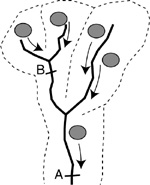
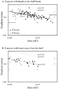
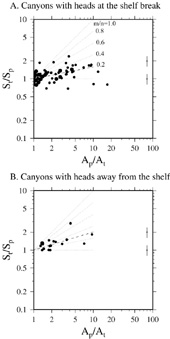
The graphs on the right show the gradient-area data for canyons reaching the continental shelf break (A) and those isolated from the shelf break (B). It is commonly thought that canyons were fed by rivers or shelf sediments during sea-level lowstands such as during the Last Glacial Maximum ("spillover"), however here the two kinds of canyon have the same gradient-area relationships. If fed by shelf sediment directly, the canyons heading at the shelf break might be expected to have become more eroded and adopted a shallower gradient at their heads leading to different average gradients, but this is not the case. This is consistent with other observations that the slope sediments are predominently muddy and don't contain abundant shelf sands as might be expected if there had been extensive spillover. If there were enhanced low-stand erosion, it may have involved enhanced supply of hemipelagic sediment across the whole slope rather than just shelf-break-heading canyons.
At a river confluence, the long-term erosion rates of the two branches must be equal, otherwise we would observe a waterfall at the confluence and the tributary would drain a hanging valley. Their contrast in areas and gradients can reveal the ratio of exponents m/n and how well the drainage system follows the erosion law (Seidl and Dietrich, 1992). Such data for these submarine canyons (graphs to the left) show significant scatter, but they suggest on average E~A^mS^n with m/n=0.2-0.3. Gradient and area are also related by a power-law relationship (S~A^-0.3) that is consistent with the erosion law if the landscape is in a steady state. Seidl, M., and Dietrich, W. E., 1992, The problem of channel erosion into bedrock: Catena Suppl., v. 23, p. 101-124. Mitchell, NC, Interpreting long-profiles of canyons in the USA Atlantic continental slope, Marine Geology, 214, 75-99, 2005. (abstract.) Mitchell, NC, Form of submarine erosion from confluences in Atlantic USA continental slope canyons, American Journal of Science, 304, 590-611, 2004. (full article (PDF).) |
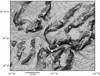
Detachment-limited erosion?In detachment-limited erosion of river beds, loose material is easily removed and erosion is limited by how fast material can be plucked or abraded from the bed. In "flow power" erosion schemes, the erosion rate is typically related to the shear stress the flow imposes on its bed or the specific flow power. Either implies that, as a river speeds up, it should become more erosive. Progressive erosion then leads to steep reaches migrating upstream over time (if lithology, fractures, etc are uniform).This image (right) shows channels cut through anticlines in the Gulf of Alaska. Whereas the range-front fault might be expected to lie along the southeast front of the southern-most ridge, the channel contains two steep reaches upstream from it and a further steep reach within a piggy back basin. Other steep sections can be found upstream of likely faults or of the SE edges of anticlines. These are evidence for upstream migration and "detachment-limited" styles of erosion. |
|
|
|
Transport-limited erosion? |
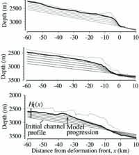
Alternatively, material within the bed is easily detached but the transport flux of sediment is controlled by the strength of the stream. In "transport-limited" erosion rules, deposition occurs where the transport flux slows down (where the channel shallows) and erosion occurs where flux increases (where the channel steepens). In alluvial channels, these effects cause the channel to smooth out.
The graphs (left) show profiles through channels of the Barbados accretionary prism (data of Huyghe et al., Geology, 2004). Compared with the profiles taken from outside the channels (dotted lines), the channel bed is indeed smoother and rounded. Some channels therefore show "transport-limited" styles of erosion.
|
Erosion by hyperpycnal flows | |
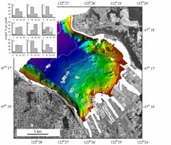
At river mouths, turbidity currents occur but it is often unclear if they form because outflowing river waters initiate hyperpycnal (negatively buoyant) flows directly or if they occur from failure of sediments rapidly deposited at the river mouth. The events occur during floods when rivers have the greatest sediment loads and consequently the processes are difficult to observe. In this dataset (right) collected by the USGS/NOAA, a series of fine gullies can be seen seaward of the river mouth and away from possible landslide sources, so this is evidence for hyperpycnal flow erosion. | Mitchell, NC, Channelled erosion through a marine dump site of dredge spoils at the mouth of the Puyallup River, Washington State, Marine Geology, 220, 131-151, 2005. (abstract.) |